In Brazil’s Pará region, new roads are cutting through the pristine Amazon rainforest, opening up once-untouched areas to human activities. Expansive stretches of lush greenery are vanishing at an alarming pace, yielding to barren patches and freshly cleared land.
Meanwhile, far into space, the European Space Agency captures high-resolution satellite images of the region that unveil an important pattern: deforestation occurs predominantly near these newly constructed roads.
Back in 2016, it sparked a question: what if there were a tool to monitor these roads and forecast potential deforestation areas? Not long after PrevisIA was born.
In 2021, Microsoft with Vale Fund and the Amazon Institute for Man and the Environment (Imazon) developed a new AI tool called PrevisIA, to predict deforestation hotspots in the Amazon. Using satellite imagery from the European Space Agency and an algorithm developed by Imazon, the tool produces heat maps showing the most exposed conservation areas, Indigenous lands, and other settlements, along with rankings for states and municipalities.
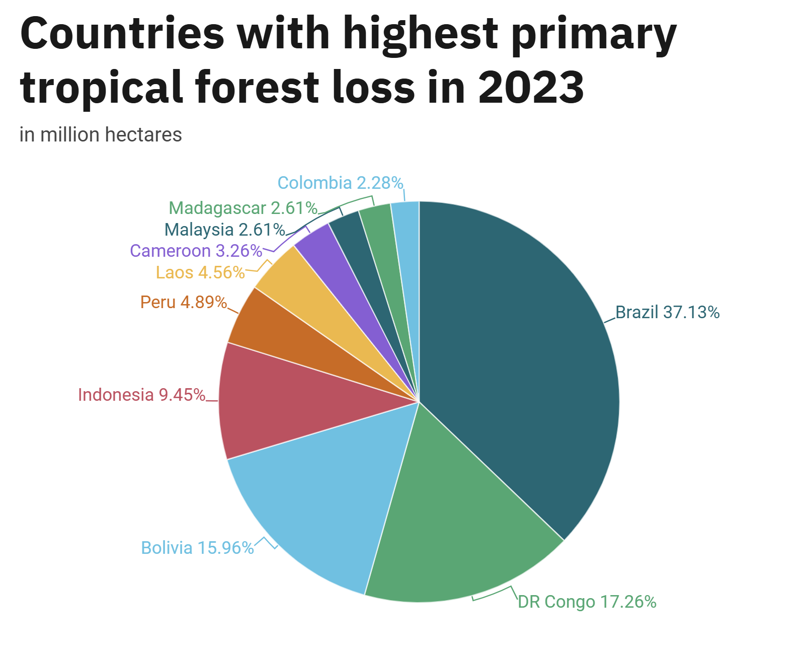
Each year, ten million hectares of forest are deforested globally – an area the size of the entire country of Hungary. About 95% of this deforestation occurs in the tropics. In 2023, the loss of tropical primary forests was 3.7 million hectares, which is comparable to losing nearly ten soccer fields of forest every minute, according to the World Resources Institute – Global Forest Review.
Deforestation contributes to global warming by reducing the number of trees that absorb carbon dioxide, a key greenhouse gas, from the atmosphere, thus increasing the amount of CO2 and accelerating climate change. According to the International Panel on Climate Change, only about ten years remain to prevent the most catastrophic effects of global warming.
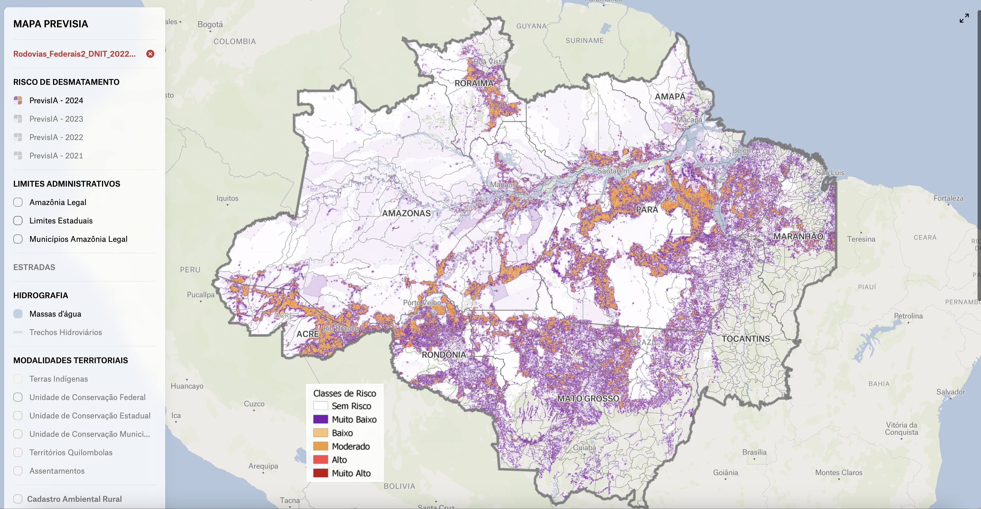
“Through intelligent algorithms in the cloud, we are able to forecast deforestation and forest fires before they happen. This is one of the biggest examples that technology can help build a better world,” Rodrigo Kede Lima, Microsoft’s president for Latin America, said at the launch of the platform more than three years ago.
PrevisIA works by using satellite images and Artificial Intelligence (AI) to look for signs like new roads being built, which often lead to tree cutting. Research by Imazon, published in scientific journals, revealed that 95% of total deforestation in the Amazon occurs within 5.5 kilometers of roads, while 90% of yearly fires happen within four kilometers of illegal roads constructed for logging, mining, and land seizures.
“Roads are really the arteries of destruction,” said Carlos Souza Jr, Senior Researcher at Imazon and project coordinator of PrevisIA and Deforestation Alert System (DAS). “Everything starts there; they don’t just go into the forest to harvest timber. Roads lead to deforestation,” he explained.
PrevisIA analyzes the data and can alert authorities before deforestation happens, which allows them to take action and prevent it – before it’s too late.
The Challenges of Traditional Forest Management
Traditional forest management practices have been used for centuries to sustainably harvest and preserve forests. Techniques like sampling, statistical analysis, and visual inspections have been effective to manage large forest areas. These methods, which are time-consuming and labor-intensive, usually provide valuable data, but the lack of real-time information means forest managers are often reacting to problems rather than preventing them. The approach is further complicated when monitoring vast or remote areas, as the delay in detecting illegal activities or environmental degradation allows damage to spread unchecked.
One example is using foot patrols to catch illegal logging or poaching, especially when covering large or inaccessible areas. By the time these activities are discovered, the harm to ecosystems can be extensive and require far more resources to repair than would have been needed to prevent the damage in the first place. The increasing ability of illegal operators to outpace traditional detection methods adds another layer of complexity, according to the Global Forest Watch – the online platform for monitoring forests.
Reforestation efforts face similar setbacks. Manual planting is usually slow and labor-intensive. When combined with high costs, it limits the speed at which deforested areas can be restored. Poor seedling survival rates further reduce the effectiveness of these efforts, especially in regions recovering from wildfires or where the terrain is challenging. The lack of real-time data makes it difficult to assess soil conditions, seedling growth, and other factors that could improve reforestation success. Meanwhile, recent research shows that reforestation needs to be done quickly and effectively, because it prevents desertification, reduces flooding and disease risks, supports indigenous communities, and helps fight climate change by capturing carbon dioxide.
Over the years challenges with conventional methods have led to the development of new technologies and approaches that aim to improve the efficiency, effectiveness, and sustainability of forest management.
How Remote Sensing is Transforming Forest Monitoring
Imagine being able to monitor the health of forests from above the Earth’s surface without ever setting foot in the forest. Remote sensing makes it possible — typically by using satellites or aircraft-based instruments. This technology captures information about the physical characteristics of landscapes, such as vegetation, soil, and water, without needing to be in direct contact. As a result, scientists are able to gather consistent, large-scale data that gives them a clear picture of forest conditions, making it easier to track changes, detect problems, and manage resources more effectively.
Today’s key remote sensing technologies include imaging, photogrammetry, radar, hyperspectral, and LiDAR (Light Detection and Ranging). These tools allow us to monitor and map forest cover, detect deforestation and degradation, assess biodiversity, monitor forest growth, estimate biomass and carbon stocks, and even manage wildfires.
A key practical use of remote sensing technologies in forest management is monitoring deforestation. One of the companies leading the effort is CTrees, the only global forest carbon and activity data platform. It has launched the Land Use Change Alert (LUCA) system, which uses synthetic aperture radar to create detailed images of the Earth’s surface and detect deforestation and other degradation events worldwide, even through cloud cover that often hinders other methods. LUCA then processes high-resolution images to monitor forest areas, applies advanced machine learning to identify disturbances, and provides alerts every two weeks.
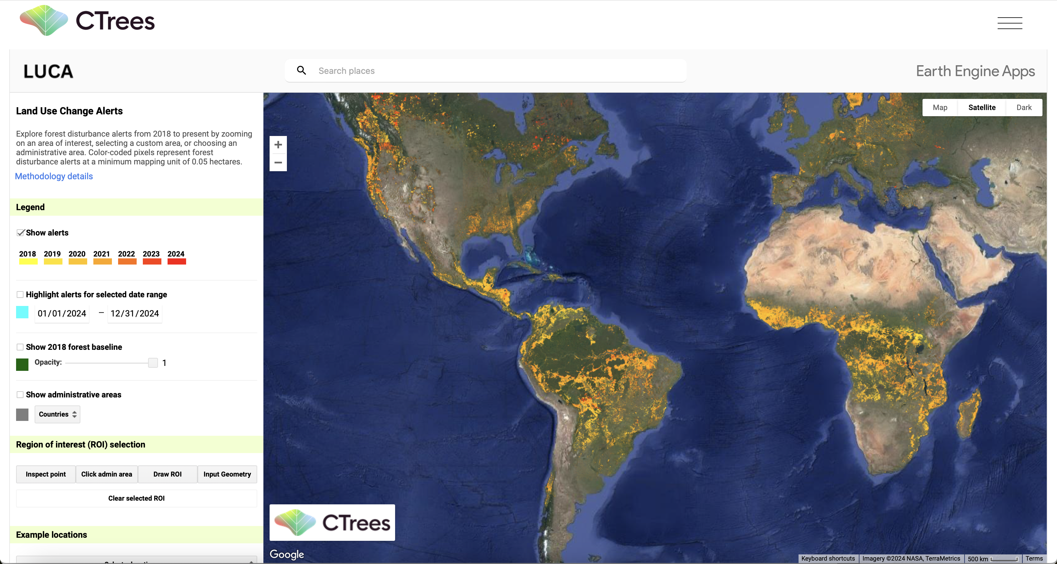
One of the areas with the most alerts since 2018 is the Amazonian rainforest.
The Amazon rainforest – the largest rainforest in the world – absorbs a quarter of the carbon stored in the world’s forests and helps regulate the planet’s climate. But ongoing deforestation threatens to disrupt ecosystems and make the region uninhabitable, leading to severe environmental consequences, Brazilian climate scientist Antonio Nobre recently told National Geographic. Though deforestation in Brazil’s Amazon dropped by nearly 50% in 2023, the lowest rate in five years, the deforested area still remains large.
The vast size of the Amazon rainforest makes it difficult to monitor through traditional methods. In 2004, Brazil introduced the DETER program, which uses near-real-time satellite data to detect and report illegal deforestation. The study estimated that from 2001 to 2015, DETER helped avoid 652,000-677,000 km² of deforestation (the size of the state of Alaska) and prevented about 1.6 trillion tons of CO2 emissions.
Cutting down trees in tropical regions releases over 5.6 billion tones of greenhouse gases annually, which is more than four times the combined emissions from aviation and shipping, according to the United Nations. Thus, it exacerbates climate change. Recent research led by carbon data provider Sylvera, in collaboration with University College London (UCL) scientists, utilized advanced 3D laser scanning techniques to reveal that miombo woodlands in Mozambique store 1.5 to 2.2 times more carbon than previously estimated through traditional methods. In the last 40 years, deforestation has shrunk these woodlands from 2.7 to 1.9 million square kilometers—an area three times larger than the UK—making continuous monitoring essential.
“Our team’s findings across Miombo woodlands is a true testament to the power of how technology can help us better understand nature to expedite investment and make real net-zero progress because we’re simply running out of time,” said Allister Furey, CEO and Co-founder of Sylvera.
Remote sensing technology is also used to track biodiversity (the variety of life in a particular habitat) – one of the main indicators of a forest ecosystem’s health. Healthy forests are crucial in combating climate change, providing essential services like carbon storage, temperature regulation, water supply, and biodiversity preservation.
Researchers, led by Chris Hakkenberg, a Northern Arizona University professor, are using a special tool from NASA called GEDI, which uses lasers from space to map forests in 3D. This gives a detailed view of forest structure and helps to predict where different plants and animals live. Understanding biodiversity trends can help us address the urgent threat of extinction facing over one million species due to habitat destruction and overexploitation.
“It is extremely urgent that we devise better ways to map and monitor biodiversity at large scales like we do for climate change. This study is a part of that greater effort, giving us a fighting chance to address these issues before it’s too late,” Hakkenberg said.
A different set of researchers are using satellite remote sensing, including LiDAR and hyperspectral imaging — analyzing a broad range of light reflected from vegetation and other forest elements — to study biodiversity in boreal forests (also known as ‘taiga’). Focusing on aspen trees in Finland, they found that remote sensing accurately predicts lichen species and offers a cost-effective way to map biodiversity compared to traditional field methods which includes manually inspecting individual trees for species and abundance.
Drones Enhance Precision and Accessibility
In 2003, 13-year-old Cameron Jones and his 14-year-old brother Bryce witnessed the Okanagan Mountain Park fire ravage their hometown of Kelowna, British Columbia, Canada. Charred snags replaced the greenery, exposing a vast, lifeless landscape that stretched for kilometers.
Sixteen years later, the brothers founded the startup Flash Forest with a goal to plant one billion trees globally by 2028. To bring that vision to life the company is using drones.
Flash Forest drones fly 130 to 200 feet above the canopy, shooting seed pods into the soil at high velocity. They can deploy five pods per second, rapidly covering large areas, including places too dangerous for humans, particularly in high-severity fire zones where natural regeneration is unlikely. The company has adapted commercial drones to fire seed pods and uses aerial mapping software to avoid areas where trees won’t grow – such as water, rocks, and paths.
Using drones for reforestation speeds up the process by at least ten times compared to human labor alone. This innovative approach addresses key issues with traditional reforestation methods, such as high labor costs and limited access to difficult terrains. The results in different parts of the world are promising so far.
In Nairobi, Kenya, the Kenya Forestry Research Institute (KEFRI) and Kenya Flying Labs (KFL) have launched drones with seed dispensers to enhance reforestation. They aim to replace traditional methods and help achieve the country’s goal of 10% forest cover by 2030. Here drones offer a cost-efficient alternative to helicopters and airplanes and are able to reach even the most remote areas. In September 2018, a project in Myanmar deployed drones to drop “seed missiles” into isolated areas lacking tree growth. Within a year, thousands of those seeds had sprouted into 20-inch mangrove saplings. In Bahia, Brazil, drones are being deployed by the startup Morfo to sow seeds in degraded areas, aiming to restore one million hectares of land by 2030.
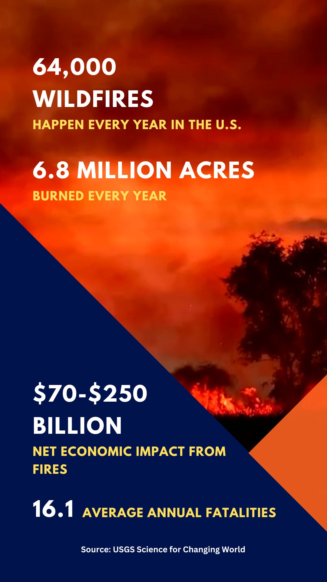
Deforestation not only destroys habitats and reduces biodiversity, but it also contributes to forest fires by creating dry, exposed land and increasing the amount of combustible materials. These can easily ignite due to rising temperatures and altered weather patterns. Fires drive tree cover loss outside the tropics.
The August Complex fire of 2020, sparked by lightning strikes across seven counties in Northern California, became the largest wildfire in the state’s history, scorching more than one million acres. With global warming lightning could spark more fires in California and elsewhere.
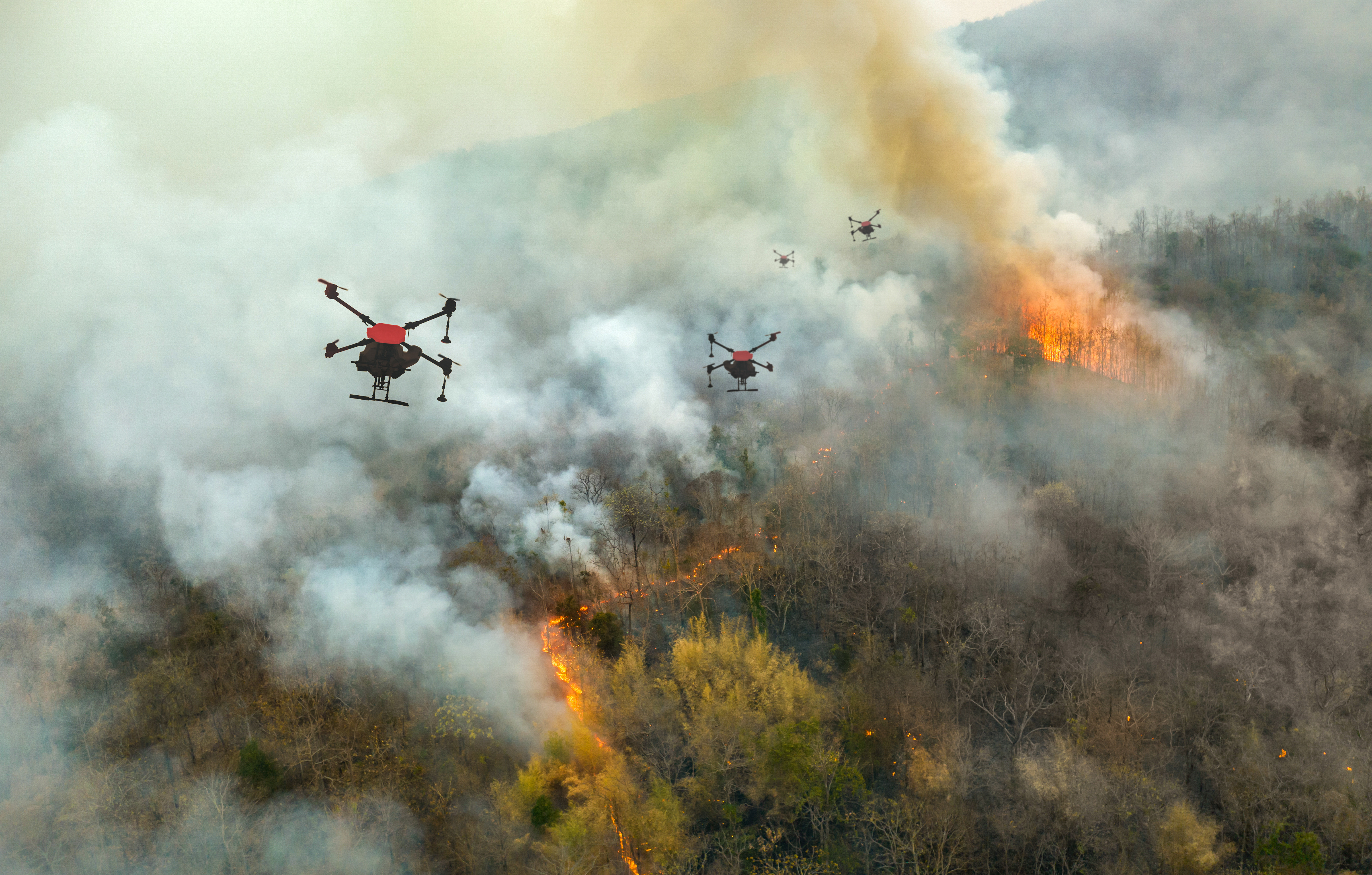
In response, the California Department of Forestry and Fire Protection (Cal Fire) and other agencies started to use cutting-edge technology like drones, satellites, and AI to predict fire movements, though challenges remain in managing the increasing severity of wildfires. Zhaodan Kong, a professor at the University of California Davis, is developing an advanced wildfire detection system to address the issue of late fire responses, which currently rely on visible smoke. Kong’s approach combines internet-connected ground sensors that monitor temperature, humidity, and wind speeds with unmanned aerial vehicles (UAVs) equipped with cameras and chemical sensors to detect fires before they become visible.
“To give you an example, sometimes when someone is grilling barbeque, you can’t see it, but you can smell it,” Kong said. “That’s what we are trying to do with the wildfires.”
Cal Fire reported a 9% increase in the number of wildfires this spring, and the area burned has surged dramatically in 2024, rising by 1,462%. An early detection system developed by Kong and his team members would alert authorities allowing them to respond faster and reduce wildfire damage. Kong told Public Health Landscape that initial tests around prescribed burns have been promising, though challenges remain in determining detection range and sensitivity.
“My dream is that, right now, we’re focusing on detection, and then there may be a way to incorporate suppression as well, “ he explained. “In that case, for small, early-stage fires, you might not even need to send in firefighters; you could just deploy all the drones automatically.”
Erika Lopez Coca, founder of the GAIA Center, and Laura Arianne Parada Hoyos, a gender and environment specialist, are leading similar efforts in Bolivia to combat forest fires using drones through the Firehawk Project. The initiative, launched in remote and rural areas, uses drone technology to map and monitor fire-prone zones, so that communities can take preventive measures and respond quickly to emerging fires. In 2023, Bolivia experienced over 42,100 wildfires – the highest in five years – and, as a result, lost nearly 700,000 hectares of natural forest.
Drones also use advanced imaging to track forest changes in real-time, detect threats like wildfires and pests, and survey large areas quickly. They provide precise data on tree species, size, and health and track wildlife for targeted conservation.
It [AI] is not doing something that we have not been able to do before, but it’s allowing us to do it much, much faster.
Emily lines, associate professor, Cambridge University
Use of Artificial Intelligence (AI) in Forest Analytics
In Canada, fire duty officers once relied on an outdated system to allocate crews and resources before predicted fires. In 2020, Alberta Wildfire began using an AI tool by AltaML to predict wildfires, analyzing weather and forest data to improve accuracy. Here the AI not only cuts costs but also helps less experienced managers make better decisions, reducing unnecessary resource use, such as hiring standby helicopters for fires that don’t happen.
Danish start-up Robotto has developed AI-powered drones that monitor and track wildfires in real-time, providing firefighters with up-to-date data to improve decision-making and resource allocation. The technology is already being tested in Catalonia and is also used for wildlife monitoring and search-and-rescue missions worldwide.
WWF-Netherlands has recently developed an AI model called Forest Foresight to predict deforestation up to six months in advance with 80% accuracy. The tool analyzes data like topography and population density and uses real-time satellite images to detect early signs of deforestation, such as expanding roads. In Gabon, it has already successfully helped rangers stop an illegal gold mine, protecting 74 acres of forest.
AI algorithms can also quickly analyze data to provide real-time insights, which helps in monitoring forest health, optimizing conservation efforts, and making informed decisions about forest management. A study in northwestern Ecuador’s Chocó rainforest utilized acoustic monitoring and AI tools to track the recovery of biodiversity in different land types, including regenerating forests. The findings showed that species, including birds and insects, returned to the forests in as little as 25 years.
“I think the most important finding is that AI models allow us to measure biodiversity levels relatively well, even in their simple versions,” Martin Schaefer, a co-author of the study and director of the Ecuadorian NGO Jocotoco Foundation, said in an interview with Mongabay.
AI-powered systems can detect illegal activities and environmental changes even without human intervention. TrailGuard AI, introduced on International Tiger Day 2022, operates in India’s Kanha-Pench Tiger Conservation Landscape, using real-time AI to monitor tigers and other wildlife and transmit images within 30 seconds. This advanced tool aids in conserving tigers, which are under threat from habitat loss and poaching.
Emily Lines, an associate professor in the Department of Geography at Cambridge University and a UKRI Future Leaders Fellow, is developing next-generation forest dynamics models utilizing remote sensing data. Her research focuses on understanding forest functions and forecasting their future through data collected from ground sensors, drones, airplanes, and satellites. Her team analyzes billions of laser-captured data points to measure Essential Biodiversity Variables (EBVs) like genetic diversity and population abundance. The AI model speeds up the processing of data from hours to minutes, allowing for quick analysis of individual trees and their characteristics.
“It [AI] is not doing something that we have not been able to do before, but it’s allowing us to do it much, much faster,” she said.
Integrating Technology with Indigenous Forest Management Practices
Besta Pulum, a community chief from Papua New Guinea, is thrilled by a new tablet that helps him monitor his forest using high-resolution satellite imagery. To the point that he couldn’t sleep at night from excitement. Following in his father’s footsteps, he has spent his 60 years of life tending to 800 hectares of thick tropical forest in the isolated western highlands of the country where the majority of the forest is owned by Indigenous Peoples.
About 36% of the world’s untouched forests, with half in tropical areas, are on Indigenous lands. Indigenous communities help protect around 80% of the Earth’s remaining biodiversity. Forests on their lands are better managed and have more diverse wildlife compared to forests outside their lands.
Just like Besta Pulum, Indigenous people worldwide struggle to protect their lands due to illegal logging, mining, and farming. They also lack the resources and support needed to monitor and safeguard their forests. Besta’s new tablet is part of the Accelerating Innovative Monitoring for Forests (AIM4Forests) program, launched by FAO and the UK government in 2023. The AIM4Forests program in Papua New Guinea works to stop deforestation and restore land by combining technology with Besta’s traditional knowledge, as part of a global effort to restore one billion hectares by 2030. With that in mind, FAO and Google have developed Open Foris Ground – a mapping tool that allows forest custodians to easily mark and monitor their land through Google Earth using a tablet or phone.
Long before modern forest management and AI drones, local and Indigenous communities used traditional methods to manage forests sustainably, adapting their practices over centuries and passing down knowledge orally through generations. A UC Berkeley study found that the forest biomass in the Klamath Mountains used to be about half of what it is today, and Karuk and Yurok tribes used fires as a forest management tool that helped maintain the forest and its biodiversity. Cultural burns, practiced by Indigenous tribes for thousands of years, are land management techniques that promote biodiversity and resilience. Later on, years of logging and fire suppression have made California’s forests vulnerable to drought, pests, and severe wildfires, worsened by climate change.
Indigenous communities in Papua New Guinea are not the only ones combining traditional knowledge with cutting-edge technology to protect forests. The Uru-Eu-Wau-Wau Indigenous people in Brazil use drones, smartphones, and camera traps to monitor and document illegal deforestation on their land. With support from WWF and the Gordon and Betty Moore Foundation, they track environmental destruction and report it using Spatial Monitoring and Reporting Tool (SMART), a customized software. Paired with their deep knowledge of the land, surveillance technology has become essential for protecting and conserving their territory.
Similarly, in Indonesia’s Aru Islands, Indigenous Aruese use satellite data to monitor and report illegal logging, leading to significant timber seizures. In Peru, Indigenous communities reduce deforestation by over 70% and speed up land title processes using satellite monitoring technologies. A 2021 study in the Peruvian Amazon demonstrates that Indigenous using smartphones and satellite data to monitor deforestation can significantly reduce forest loss. The research showed a 52% reduction in deforestation in the first year and 21% in the second year among communities using this technology compared to those that did not.
Challenges and Future Prospects
Many regions still face significant technological access and infrastructure gaps that hinder the effective deployment of advanced forest management tools. Limited internet connectivity and energy shortages can create barriers to utilizing these technologies, especially in remote areas where they are often needed the most. Insufficient technical support and training can prevent local communities from fully harnessing the potential of these innovations, ultimately limiting their impact on forest conservation efforts.
In addition to infrastructural challenges, the high costs associated with acquiring and maintaining advanced technologies like AI, LiDAR, and hyperspectral imaging, pose a significant barrier for many forest management programs. Budget constraints often limit the ability of organizations to invest in these tools, despite their potential to provide valuable insights for sustainable forest management. This creates a dilemma for stakeholders who must prioritize resource allocation while striving to integrate cutting-edge technology into their conservation strategies.
The industry also faces challenges when new technologies are used without the grounding of field experience. While these tools can enhance data collection and analysis, they cannot replace the nuanced understanding and practical insights gained from years of hands-on experience. Effective forest management requires integrating technology with the expertise of seasoned professionals who can interpret data accurately and apply it meaningfully. The key is to use technological advancements to support, rather than replace, experienced foresters, ensuring both effective and sustainable forest management.
Using AI-powered drone technology for biodiversity measurements faces several challenges. One major limitation is its inability to measure animal species, focusing instead on forest structure, which serves as proxies for biodiversity metrics. Experts stress that accurate assessments still require ground-truth data, as claims about the precision of AI-generated satellite data can be overstated, with potential inaccuracies of up to 30%. Additionally, while AI can improve efficiency and reduce labor, it cannot fully replace the crucial input of skilled personnel in data collection.
Emily Lines highlighted the limitations of using AI, specifically in analyzing high-resolution remote sensing data for forest ecosystems. While AI can significantly accelerate data processing compared to traditional methods, it still heavily relies on quality ground and training data to ensure accuracy.
“We always need ground data. We need training data… The quality of AI products depends very highly on their training data.”
Lines stated that “unsupervised learning has a lot of potential in ecology,” noting that it can help researchers detect patterns in complex datasets without the need for labeled training data. This approach could uncover insights that might be overlooked with traditional supervised learning methods, especially in diverse ecosystems.
“Years ago, there was a big gap in technology, but I don’t see that as the case now,” said Carlos Souza Jr.
He noted that tools like Previsia have the potential to expand beyond the Amazon. The system is already being applied in other regions like Africa and Southeast Asia.
“I usually say we want to get our tests wrong. We don’t have to be right. But if this happens, it’s because there is information that allowed us to prevent deforestation. This can result in avoiding deforestation, avoiding emissions to the atmosphere, and preserving biodiversity,” Souza concluded.
Experts agree that a balanced approach that combines innovative technology with traditional methods is essential for reliable assessments in forest management.
